THOUGHT LEADERSHIP
Buying time: managing risks with flood forecasting
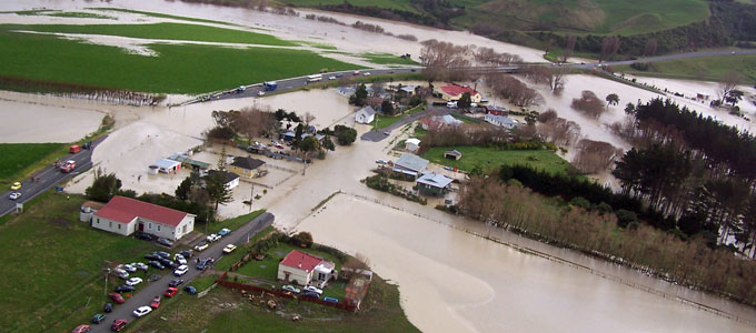
Almost every day, somewhere in the world, floods are putting lives at risk and causing major damage and financial impacts to buildings, critical infrastructure, agricultural land and crops, and the environment.
In 2013, almost 10 000 people were killed worldwide by flooding, and the lives of more than 32 million people were adversely affected by flood disasters. In Australia alone, the estimated cost of flooding is $400 million per year, and around the world the costs rise into the billions.
If you understand the specific risks and consequences of flooding in your location and area of operation, you can implement suitable emergency action plans to best manage these potentially catastrophic events, saving lives, reducing costs, and minimising impacts on property, infrastructure, communities and the environment.
Flood forecasting is a vital component of a total flood warning system. With increasing severity and frequency of extreme weather events likely in the future, effective flood forecasting systems are urgently needed to provide the accurate and timely warning of impending flood events that will improve public safety and minimise flood-related damage and costs.
Flood forecasting systems allow you to manage risk
Flood forecasting systems can be used by local authorities, water managers and owners of water assets to better manage a range of risks. By providing warning time of an impending flood, forecasting systems offer a window of opportunity for good decision making to reduce public safety risk through warning or evacuation, and to ensure informed management of water infrastructure.
Whenever a large volume of water is held or is transferred under pressure, potential risks to public safety and downstream infrastructure arise. The normal operations of water assets such as dams, pipelines and hydropower facilities regularly involve potential risks to the safety of both the general public and staff involved in construction, operation and maintenance. In this context, successful flood forecasting has obvious application, such as allowing operation of a dam to minimise flood peaks downstream, informing the timing or method of dam construction to avoid inundation of the works, or helping determine the need for emergency evacuation.
Sometimes flood risks can also be opportunities, if managed carefully. Flooding offers the gift of abundant flows to owners of hydropower assets or water supply or irrigation storage facilities. In this context, flood forecasting can provide strategic operational benefits to water managers by providing enough warning of impending large flows to allow optimal preparation for capturing, storing and using the plentiful water.

How are floods predicted?
Flood forecasting systems combine measured rainfall data and rainfall forecasts from weather forecasting agencies into a hydrologic model of a catchment. This model converts the rainfall into runoff and flow in rivers, or inflows to storages. These flow forecasts can be corrected with measured flow data in real time where this is available.
For some applications, these flows provide inputs to a hydrodynamic model of the river and surrounding area to give forecast flood levels and inundation areas.
The forecasts can then be displayed graphically or in another appropriate format for operators and water managers to use to manage flood risk.
The accuracy of flood forecasting depends on both the accuracy of the input data (rainfall, forecast rainfalls and flows) and the accuracy of the hydrologic modelling.
There is a necessary trade-off between forecast times and accuracy. The most accurate forecasts are based on measured flow data, but this gives very little warning time as the flows are already in the river. Forecasts based on conversion of measured rainfall to runoff using models give longer warning times but greater uncertainty. The longest warning times are achieved using forecast rainfall data, but these forecasts are the least certain.
Despite greater uncertainty, longer term forecasts can indicate that a water manager should keep watch for the possibility of a flood, and can offer more time to ensure that the correct procedures are in place to manage a potential flood risk, and to take actions such as optimum storage management to capture floods.
Best practice for successful flood forecasting systems
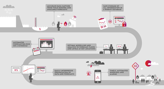
Successful real-time flood forecasting relies on capturing and storing accurate input data, reliable modelling, easily interpreted results, and timely alerts and warnings. Best-practice flood forecasting systems should include:
|
Accurate data capture from field sensors and available forecasts
|
Data collection sites for flow, rainfall and water-level information must be properly maintained, and any problems with sensors quickly addressed. Automated quality checking is needed to detect major data errors or missing data. There should be redundancy in the network, and routines within the modelling should allow for infilling with data from other sites if one site is out of service. Ideally, a range of possible rainfall forecasts would be included in the modelling to indicate uncertainty in forecast rainfall amounts. |
| Safe storage of all information in a robust database | Storing all data used in forecasting, and the forecasts themselves, allows analysis of the suitability of the input data for forecasting, and analysis of the accuracy of forecasts. Comparison of forecast and actual data can be used to adjust the models. |
| Optimal modelling and analysis to forecast flows and levels at key locations | Hydrologic and hydrodynamic modelling provide flows and water levels at critical points in the system, such as an inflow to a storage, the water level in a reservoir, the water level along a river, or an inundation area in a town. Models should be reviewed periodically with the most recent data to ensure that the parameters are still optimal and that the forecasts are performing as expected. |
| Automated forecasting run on a schedule | The forecasting system should be fully automated, with the ability to run more frequently in a flood situation if required. Where practical, the system should be fully redundant. A stand-alone system operable with manual data inputs can provide back-up if all communications to a site are lost. |
| Easily interpreted presentation of data and forecasts | Operators and managers need to be able to easily interpret forecasting outputs to make decisions. The visualisation of the data should be tailored for the individual user and include an indication of certainty. Displays may include maps of forecast inundation areas, forecast river levels and flows, or rainfall over a catchment. |
| Timely, automated warnings and alarms | Automated alarms and warnings alert water managers of any forecast floods that may exceed critical thresholds, providing time to ensure appropriate preparation and action. |
Applications of flood forecasting systems
Flood forecasting is a critical part of managing dam risk and public safety risks across a dam portfolio. As part of Hydro Tasmania, Australia’s largest water manager and renewable energy producer, specialist power and water consulting firm Entura provides real-time inflow and flood forecasting and data management solutions to help manage Hydro Tasmania’s own extensive catchments and a complex system including 55 major dams.
We’ve built on our experience in dam safety to offer flood forecasting expertise to a range of clients throughout the Asia-Pacific region for other important applications, such as providing the advanced flood warnings needed to protect assets and communities at risk, whether in regional areas or large metropolises.
To find out more about how Entura can partner with you to develop a tailored and complete solution to help you better manage your flood-related risks, contact David Fuller on +61 438 559 763 , Phillip Ellerton on +61 439 010 172 or Shekhar Prince on +61 412 402 110.
MORE THOUGHT LEADERSHIP ARTICLES
11 August, 2015


