New technologies give deeper insight to protect the shallows

Water is a precious resource for communities and industries – and for the health of river ecosystems. Balancing these needs around dams can be very complex. In this article, Dr Will Elvey and Dr Colin Terry explore how advanced technologies and methods can help dam owners/operators better understand shallow downstream areas to support aquatic biodiversity …
Dams are crucial for many communities, providing water security, energy and economic growth – but they also change the natural flow of rivers and streams.
To preserve downstream ecosystems and species, ‘environmental flows’ (e-flows) began to be implemented in hydropower operations from the 1970s and the concept became more sophisticated and more formalised as the decades rolled on. In Australia, e-flow assessments are now typically required by state or Commonwealth regulators for new dam projects or major operational changes.
These assessments are complex and challenging both for new developments and for retrofitting existing schemes. As the concept of e-flows continues to evolve, methods of modelling and assessing these flows must evolve too.
Getting a deeper understanding of what’s downstream
Scientific understanding of the ecological requirements of freshwater species and the physical processes that shape their habitats has advanced significantly since e-flow studies began. Many aquatic species exhibit preferences, or even strict dependencies, on specific velocities and depths. To accommodate those preferences or dependencies, it’s vital to better understand how habitat availability and quality respond to different e-flow regimes (i.e. the timing of discharge and the diversity of velocity and depth across the channel).
There are many approaches for simulating habitat changes under varying flow conditions, but all rely on hydraulic models. E-flow assessments are often constrained by the capabilities of the hydraulic models used, and simpler models are generally inadequate for addressing complex ecological questions. Attempts to use simple models to inform more detailed ecological metrics, such as habitat preference curves for individual species, often fail to deliver the intended environmental outcomes.
Using simple models can lead to adopting basic flow rules, where benefits are difficult to quantify beyond broad estimates (e.g. maintaining wetted channel widths or meeting minimum depth thresholds). The inherent limitations of simplistic hydraulic modelling can also make it difficult to justify proposed environmental water releases to regulatory agencies and water resource managers.
Simple models suit simple questions only
Early environmental flow studies commonly used one-dimensional (1D) hydraulic models, which assume uniform water properties across the channel and throughout the water column, varying only along the main flow direction. But in reality, the shape of a watercourse and its hydraulic properties are too variable to be able to be simulated well by 1D models.
Shallow water zones in rocky riverbeds – which are often highly ecologically diverse and are vulnerable in droughts or insufficient flows – are particularly hydraulically complex.
1D models are still used and do provide useful general information such as wetted cross-sectional area, average velocity, and minimum and maximum depths. However, they lack detail about vertical and lateral flow dynamics and can’t simulate water movement around complex in-channel structures like rock substrates or little waterfalls.
This means that 1D models are best suited to answering relatively simple questions – for example, how different discharge changes the wetted area, or what the maximum and minimum depths and velocities are for a cross-section.
1D models, when configured with sufficient cross-sections through complex areas of riverbed, can more effectively address questions such as whether minimum depths allow fish to pass through shallow reaches during low flows, or whether velocities are sufficient to support macroinvertebrates that thrive in faster flowing areas, such as stoneflies, mayflies, caddisflies, elmid beetles and some dragonfly species.
Estimating water velocity is crucial for understanding how physical habitat is maintained through the mobilisation of bed particles, from the fine silts to the largest rocks.
The accumulation of fine sediments on surfaces, and within the spaces between and beneath rocks, can degrade habitat quality for many aquatic species. Simulations of water velocity and associated shear stress can help determine whether flows are sufficient to transport fine sediments away from riffle habitats.
At the other end of the spectrum, annual peak flows of sufficient magnitude to mobilise larger substrate classes (from gravels to boulders) play a key role in maintaining healthy river systems. However, the low spatial resolution and limited physics of 1D models means they can only contribute to general estimates of bed mobilisation.
New technologies reveal more detail – informing better e-flows
Emerging field observation methods and computer modelling approaches that are more sophisticated and detailed can better guide environmental releases, particularly where the riverbed slope and substrate vary. These environments require a deeper understanding of the dynamics of shallow flow to support ecologically meaningful outcomes.
In the past, field measurement was limited to point surveys at cross-sections, and computers only had the capacity for modelling 1D versions. Now, with accurate airborne drone surveys using photogrammetry and LiDAR, scientists can better describe the physical geometry of a watercourse.
Advanced computer hardware and 3D modelling software are enabling a more accurate – and more rapid – understanding of water behaviour. It is now possible to create a plausible 3D time-varying version of the water flow, with detail that enables aquatic scientists to provide better advice on appropriate environmental flows. Fewer limitations generally leads to more cost-effective insights and, in turn, better management of environmental values.
Modern methods in practice
This example demonstrates the power of evolved methods and new technologies.
A 600 m stretch of a river that is approximately 20 m wide, with a rocky bed, was surveyed by drone, capturing 1,260 images which were used to create a highly detailed 3D version of the river’s geometry. Then, using 2D and 3D hydraulic software, different flows in the test area were simulated, ranging from a trickle to larger floods. The critical flows for healthy aquatic life are the diverse shallow flows in areas large enough to allow an abundance of diverse life.
Figure 1 gives a typical view of the river. Figure 2 shows samples of the geometry captured and processed. Figure 3 shows output from the 3D hydraulic modelling software.
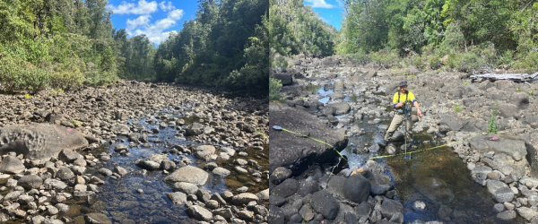
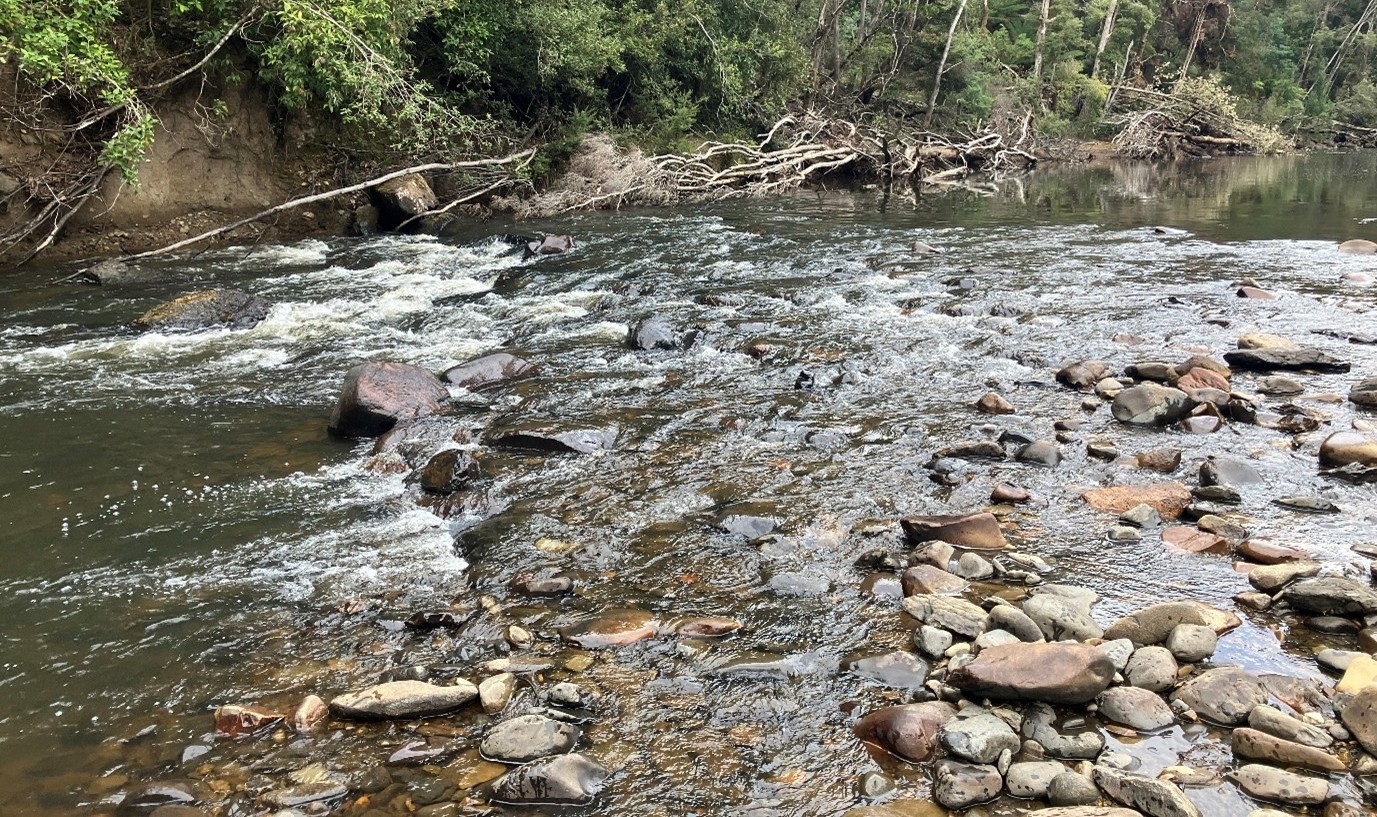
Figure 1. River at low-flow gauging (0.0077 m³/s) site looking upstream and downstream
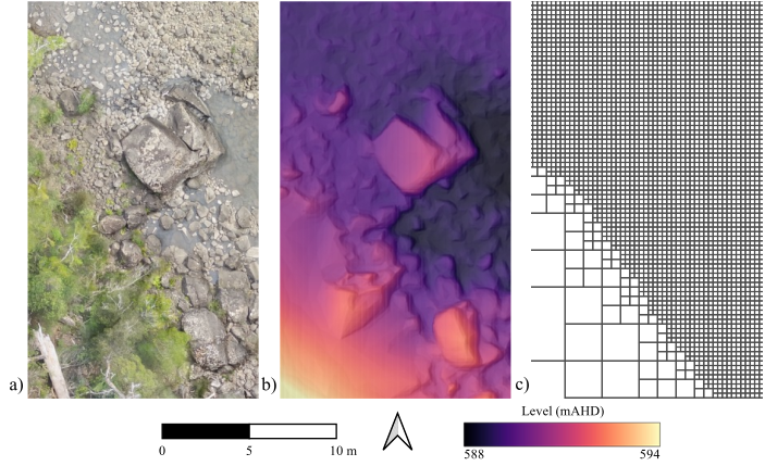
Figure 2. a) Aerial image, b) DTM, c) 2D grid, for the same area of river
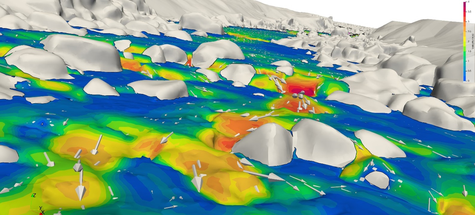
Figure 3. Water surface with scaled velocity vectors, looking upstream for 3 m³/s (3D model)
Find out more about the evolution of the e-flow concept and assessments
Find out more about river habitats and the importance of shallows for aquatic biodiversity
ABOUT THE AUTHORS
Dr Will Elvey is a Senior Environmental Scientist with Entura specialising in aquatic invertebrates, freshwater fish, freshwater habitats and ecohydrology. Will has nearly three decades of experience as a consultant in Tasmania and the United Kingdom. He has been involved in a wide range of projects that include assessing impacts of stressors on aquatic ecosystems.
Dr Colin Terry is Entura’s Senior Principal, Water (Hydraulics/Hydrology). Colin has over three decades of engineering experience, most with a water focus. He has expertise in water modelling, design and planning of dams, hydropower and water infrastructure, including 3D CFD analysis of hydropower intakes, rivers and dam spillways. Colin has worked at senior technical levels of small and large organisations across Australia and New Zealand.
25 September, 2025


