THOUGHT LEADERSHIP
Five steps to better understanding geological risks in hydropower projects
Not fully understanding the geological conditions is one of the biggest risks in a hydropower project, and can lead to large cost blow-outs, major repairs and even public safety issues.
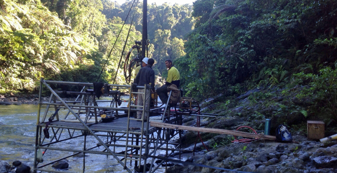
Understanding the geological conditions enables engineers to design safe and stable structures, and to minimise project and financial risk. The geological risks don’t stop at the dam site, but also extend to the spillway, powerhouse, tunnels and other structures.
Hydropower developers often ask: ‘how much should I spend on geological investigations for my hydropower project?’ and ‘how many drill holes do you normally need for a dam site?’
The answer depends on what is already known and what risks have been identified through the available regional geology and the geological mapping of the site. Geological investigations aim to understand the risks at the site by progressively developing a geological model.
Five steps to achieving a good geological model
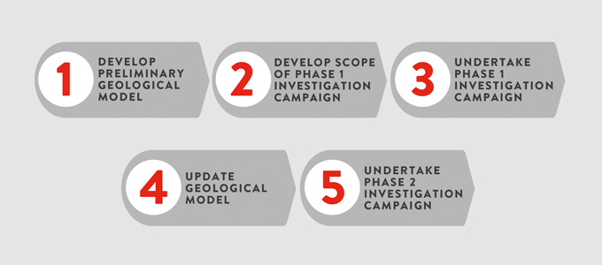
It is important to have a clear, systematic process to achieve a good geological model and, therefore, ensure that the subsurface geological risks are well defined.
Entura has developed and adopted the following five-step process:
Step 1 – Develop preliminary geological model
The first step is to develop a preliminary geological model of the site based on available geological information, aerial photos, topographic data and geological surface mapping. Spending the necessary time to source and collate all the available information is valuable.
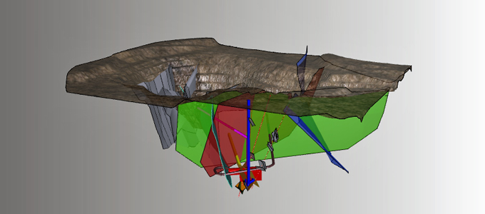
The model should include not only the geological units but also the main defects such as bedding, joints, shears and faults. Understanding the main defects helps to determine whether there are any potential failure mechanisms within the foundations underlying the project structures.
Step 2 – Develop scope of phase 1 investigation campaign
Based on this preliminary geological model, we can determine what needs to be confirmed or known, and then plan the phase 1 investigation campaign. The investigations must relate strongly to what you are trying to confirm or determine with the geological model. Without this strong relationship, the developer may be wasting money.
The investigation techniques planned depend on many factors including known geological conditions, information gaps, environmental constraints, site access, available skills and equipment, time and cost. There should be a clear objective for every test pit excavated, geological hole drilled, geophysical survey performed and laboratory test undertaken.
The outcome of Step 2 is the scope of works for the phase 1 investigation campaign. The development of the scope of works is a task in itself and should be performed by a suitably qualified engineering geologist. The preparation of a scope of works ensures that the developer can call for quotations from prospective consultants and contractors with confidence that the campaign will be targeted at improving the understanding of the identified geological risks.
Step 3 – Undertake phase 1 investigation campaign
The third step in developing a good geological model is to undertake the phase 1 investigation campaign.
The investigation campaign should be supervised by an appropriately qualified engineering geologist who is empowered to direct the investigations contractor and who has the flexibility to adjust the investigations as necessary based on the site observations.
For example, the core is not the only result of a drilling excavation: drilling rates, water loss, the colour of drill cuttings, hole collapse and groundwater levels all provide important information that is not visible in a core tray.
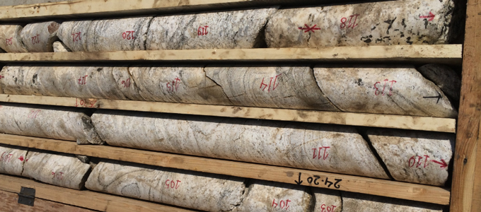
Local contractors are commonly engaged for geological investigations due to the need for heavy excavators and drill rigs. The contractors must be experienced with well-maintained equipment that is appropriate for the task (hole size, hole depths and geological conditions). Appropriate drilling techniques are required to maximise core recovery in the areas of interest, even if they take some time.
Developers must not underestimate the challenges of site access. A significant amount of time can be lost repairing broken plant in remote locations, so the proposed plant should be inspected and tested before site mobilisation.
Laboratory testing should only be performed at reputable laboratories, otherwise there is a risk of destroying samples and wasting time and money for little benefit. Typically, we use local laboratories for common tests, such as those used for concrete manufacture or road construction, and we may use specialised laboratories for more complex or unusual testing.
The outcome of Step 3 in our five-step process is significantly more factual geological and geotechnical information.
Step 4 – Update geological model
Step 4 is to interpret this additional factual information, and to update the preliminary geological model (developed in Step 1). This will improve understanding of the geological risks at the site, which is the key return on the investment made in the investigation program.
Step 5 – Undertake phase 2 investigation campaign
Step 5, the final step in the process, is a phase 2 investigation campaign. It is very common for hydropower projects to undertake more than one geological investigation campaign. This is because the geological model may change due to the information discovered in the first campaign, which may raise further questions or unknowns.
The second campaign, if required, is likely to be very focused, as it will be addressing a specific question, and will help to finalise the geological model.
Asking the right questions
Rather than asking how many holes are normally drilled for a dam project or how much money is normally spent on geological investigations, hydropower developers should ask: ‘is the money being spent wisely and for a clear purpose?’
Geological investigations do not reduce geological risks; they merely improve the understanding of the risks. A good understanding of the geological conditions reduces the uncertainty of capital cost, and therefore enables developers to make well-informed and less risky investment decisions.
To discuss how Entura can assist you to better understand the geological risks to your hydropower project, please contact Shekhar Prince on +61 412 402 110 or Richard Herweynen on +61 3 6245 4130.
About the author
Richard Herweynen is Entura’s Technical Director, Water. Richard has three decades of experience in dam and hydropower engineering, and has worked throughout the Indo-Pacific region on both dam and hydropower projects, covering all aspects including investigations, feasibility studies, detailed design, construction liaison, operation and maintenance and risk assessment for both new and existing projects. Richard has been part of a number of recent expert review panels for major water projects. He participated in the ANCOLD working group for concrete gravity dams and is the Chairman of the ICOLD technical committee on engineering activities in the planning process for water resources projects. Richard has won many engineering excellence and innovation awards (including Engineers Australia’s Professional Engineer of the Year 2012 – Tasmanian Division), and has published more than 30 technical papers on dam engineering.
MORE THOUGHT LEADERSHIP ARTICLES
24 October, 2016

