LATEST NEWS
Entura crunches the numbers to better understand Tasmania’s West Coast rainfall
15 November, 2023
This week, two of Entura’s water specialists presented at the Hydrology and Water Resources Symposium of Engineers Australia’s National Committee on Water Engineering, which was held in Sydney over 13-15 November.
Their study focused on better understanding extreme rainfall events affecting Bastyan Dam, a Hydro Tasmania dam located on the Pieman River on the West Coast of Tasmania.
“All dams need to be regularly reassessed in terms of their risk position,” said Ben James, Graduate Water Engineer. “An important part of this assessment is ensuring that the dam can withstand floods and other extreme weather events.”
“It’s vital to continually revisit our projections of rare rainfalls using contemporary methods so that we can understand whether the dam’s design and condition remain safe.”
Bastyan Dam has a catchment area of approximately 1,400 km<sup>2</sup>. It is located in the only area where the standard methods applied elsewhere in Australia to estimate probable maximum precipitation cannot be used. This is because of the uniqueness of the West Coast of Tasmania in terms of its weather patterns compared to the rest of the continent, and the sparseness of rain gauges in the region.
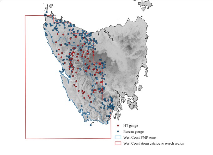
Spatial distribution of available rain gauge data.
Without a standard method to apply, Entura’s team looked closely at the rainfalls at a number of key sites within or near the catchment where historical rainfall data was available. Together with Rory Nathan from the University of Melbourne, they applied a sophisticated statistical analysis leading to a projection of the potential rainfall and its distribution, frequency, and level of uncertainty.
“This was less straightforward than it might sound and we had to be pragmatic,” said Ben.
“We were working with data from 443 sites and gauges, some of which had been read daily and some of which provided continuous data. Some of these records extended back as far as 1880, others were from ghost towns created by the boom-and-bust cycle of mining in the area. Many sites had significant data gaps where records were missing. To maximise the amount of useable information, we processed and checked an enormous amount of data, including disaggregating multi-day rainfall totals to make them comparable to single-day totals, and assessing whether some of the incomplete datasets were still useful to include. This process required weeks of intensive work.”
“The detailed examination of historical rainfall performed for the West Coast region has increased our confidence in the outcomes of the Bastyan study, and the assessed long-term safety of the dam,” he said.
The paper presented at the Sydney symposium is the first part of a longer project. The second stage of the work involves the use of these estimates and other inputs to obtain probable maximum precipitation estimates by statistical analysis. This part of the work is nearing completion.
“We’ve just got to the point of getting results for the study,” said Ben. “This has been very exciting; following months of work to derive inputs for the analysis, we’re finally getting a feel of what the outcomes might be for the dam.”
The paper presented at the conference is Regional Rainfall Frequency Analysis for Tasmania’s West Coast, by Ben James, Prafulla Pokhrel and Rory Nathan.


