River Ouse 3D CFD hydraulic assessment
Client: Hydro Tasmania
Location: Liawenee Canal offtake, River Ouse, Tasmania
Services: Hydraulic assessment, 3D computational fluid dynamics (CFD) modelling
Providing detailed hydraulic inputs to inform a resilient repair design for critical water infrastructure
Background
The Liawenee Canal offtake is located on the River Ouse, where the canal is conveyed as a raised flume above the river channel and protected by an access road supported by gabion walls. During a significant flood event in mid‑October 2022, the access road and associated gabion protection were damaged.
Before repair designs could be developed, Hydro Tasmania required a detailed understanding of flow behaviour, velocities and flow directions around the canal offtake, access road and gabion structures during major flood events. In particular, there was a need to quantify the hydraulic forces acting on the damaged infrastructure to support the design of robust and resilient remedial works.
Solution
Entura was engaged to undertake 3D computational fluid dynamics (CFD) modelling of the River Ouse in the vicinity of the Liawenee Canal offtake to provide detailed hydraulic inputs for the structural design of repair works.
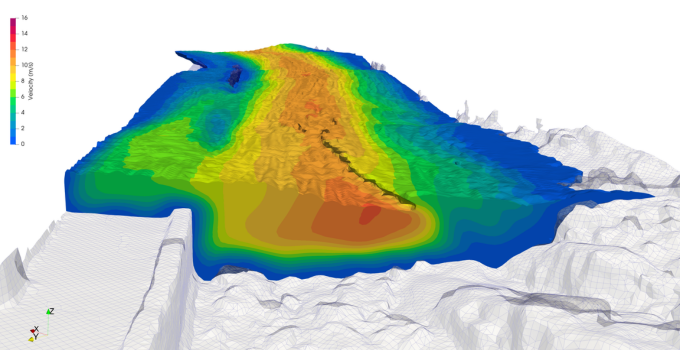
Our team developed a CFD model to simulate the hydraulic conditions associated with a historical 1-in-100 annual exceedance probability (AEP) flood event. For this scenario, it was assumed that the full flow remained within the River Ouse, with no discharge entering the Liawenee Canal.
We developed the model geometry using a combination of high‑resolution photogrammetry and existing survey data. The photogrammetry captured the as‑constructed geometry of the access road and gabion walls. This was processed into a digital surface model with a surface resolution of approximately 100–200 mm to accurately represent vertical faces. We incorporated a previous riverbed survey to define channel geometry in areas where the photogrammetry data was affected by noise
We ran the model with a constant inflow until hydraulic equilibrium was achieved. Boundary conditions were set to represent upstream water levels just above the weir crest, with appropriate downstream tailwater conditions. Our modelling outputs included detailed predictions of water levels, velocities, flow directions and turbulence in the vicinity of the canal offtake and access road.
Outcome
Our CFD modelling clearly demonstrated the river flows, flow directions, and depth and surface velocities that could occur during a 1-in-100 AEP flood event. These results provided critical design inputs for assessing erosion risk and evaluating the stability of proposed repairs.
Following our hydraulic assessment, a significant rock protrusion that was elevating water levels and velocities along the gabion wall was removed, and localised damaged sections were replaced with mass concrete blocks dowelled into no‑fines concrete. These remedial works, informed by our CFD modelling, have proven resilient during subsequent high‑flow events, providing confidence in the long‑term performance of the repaired infrastructure.
Key benefits
- Detailed understanding of extreme flow behaviour at a complex canal offtake
- Quantification of velocities and flow directions to support structural design
- Targeted, evidence‑based repair solutions
- Improved resilience of critical hydroelectric infrastructure
CFD results of the River Ouse looking downstream, showing water surface and a section coloured by velocity
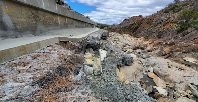
Damage to gabions from the mid-October 2022 flood, looking downstream in the River Ouse, with Liawenee Canal on the left (prior to repairs)


