Lake Rosebery 3D modelling
Client: Hydro Tasmania
Location: Lake Rosebery, Tasmania, Australia
Date: 2025 - 2026
Modelling a freshwater lake’s behaviour to predict oil movement, guiding emergency response and clean-up efforts
Background
Lake Rosebery is a scenic reservoir on Tasmania’s West Coast and a crucial component of Hydro Tasmania’s Pieman Power Scheme. Impounded by the Bastyan Dam, the lake acts as a central catchment, directly fed by the upstream Mackintosh power station.
In January 2025, oil was spotted on the surface of Lake Rosebery. This triggered an emergency response involving Hydro Tasmania as the custodian of the lake, the Environmental Protection Agency (EPA) and other agencies. To aid the clean-up process and inform operational decisions, Hydro Tasmania engaged Entura to develop a hydrodynamic model to simulate the lake's behaviour and predict oil distribution.
Services
“These models are highly data-intensive, requiring spatial, flow and climate datasets as well as a range of other inputs.”
- Joseph Holloway, Water Resources Engineer
In a matter of days, our specialists sourced and validated the required datasets, identified the key modelling assumptions and constructed a hydrodynamic model. The model was then tested for accuracy using past weather events (hindcasting) to demonstrate it could accurately recreate the observed outcome.
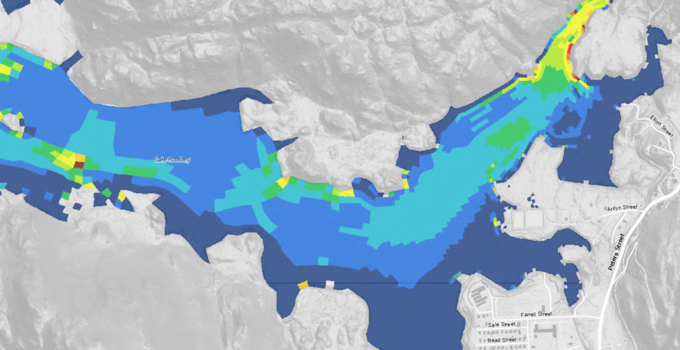
Given the urgency of the project, a key challenge was balancing the model’s accuracy with the need for timely insights. As the model's purpose was to help indicate the path the oil would take, our team simplified the approach, representing the oil as a passive tracer. The tracer, which acts like digital food dye in the water, allowed us to track the lake's flow patterns without altering the properties of the water.
As the properties of the oil were unknown, fully modelling its behaviour would have added significant complexity to the model and required an additional few weeks of work that would not materially improve decision-making. The tracer was used instead, providing an efficient and suitably accurate indication of how the spill may move within the storage.
As tracers move throughout the full water column, unlike oil, which typically remains on the surface, our analysis focused specifically on surface flow patterns to ensure the results remained practical and relevant for response planning.
Outcome
Entura delivered a functional hydrodynamic model in time to play a key role in the urgent oil spill response and support Hydro Tasmania’s operational decision-making.
By predicting the likely path of the oil using a tracer-based approach, the model reduced uncertainty in the clean-up effort and allowed resources to be deployed more effectively. It also provided valuable insight into appropriate lake levels and upstream power station operations, helping to minimise environmental impacts and support a coordinated response.
Beyond supporting the immediate response effort, the project demonstrates the value of rapid-response hydrodynamic modelling as a decision-support tool for environmental incidents. As Hydro Tasmania noted, “the biggest opportunity through Entura’s work is the potential for future application of rapid response modelling to inform incident response on any freshwater contamination.”


